- HOME
- MONUMENT
- Convent of Christ
- History
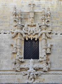
- Architecture
- Personalities
- King Afonso Henriques
- D. Gualdim Pais
- King Dinis
- King John I
- D. Lopo Dias de Sousa
- King Duarte
- Prince D. Henrique (Henry
- King John II (1455 - 1495
- King Manuel I (1469 - 152
- Diogo de Arruda
- João de Castilho
- Jorge Afonso
- Olivier de Gand
- King John III (1502 - 155
- Diogo de Torralva
- Friar Anthony of Lisbon
- Baltazar de Faria
- Filipe Terzi
- Philippine Dinasty
- King Philip II of Spain
- King John IV
- Domingos Serrão
- Queen Mary II
- Prince Fernando
- Costa Cabral
- Artisans and Artists
- Intangible Heritage
- Related Heritage
- Glossary
- VISIT OUR MONUMENT
- HERITAGE LEARNING
- TOMAR
- MONASTERIES ROUTE

Tomar Today
A few data about Tomar municipality:Region: Centre
Sub-region: Mid-Tagus
Old Province: Ribatejo
District: Santarém
Area: 351,2 Km2
Population: 43.006 (Census 2001)
Demographic Density: 122 hab/Km2
Nr. Of Parishes: 11
Orago: Santa Iria
Municipal Public Holiday: 1st of March
Tomar council is situated on the right bank of Zêzere river (main tributary of the river Tagus), is crossed by the Nabão river that divides the town of Tomar. It is a natural area of great heritage and tourism value, also integrating Albufeira de Castelo de Bode.
The council of Tomar presents an irregular distribution of the population by parish, being the parish of Santa Maria dos Olivais (741 inhabitants / Km2) the one registering the highest numbers in this index. Then, it is followed by the parish of S. João Baptista (466 inhabitants / Km2). The parishes located to the southwest, Asseiceira, Paialvo, Madalena and Carregueiros, have numbers between 100 to 200 inhab./Km2. São Pedro, Junceira, Casais, Além da Ribeira and Alviobeira are a set of parishes whose population density ranges from 60 to 100 hab./Km2. The remaining parishes, Sabacheira, Pedreira, Olalhas and Serra, have the lowest numbers (20 to 60 inhabitants /Km2).
SERVICES - ACTIVITIES
HIGHLIGHTS